
NASA graphic of their Earth Science Satellite Fleet
By Jenny Brandt and Kelly Wilkins
In April, EDGI received a grant from Earth Science Information Partners (ESIP) to participate in the recent UNBOUND (Understanding Needs to Broaden Outside Use of NASA Data) Environmental Justice Workshop series, which was hosted by ESIP and NASA’s Earth Science Division.
During the workshop, NASA shared that their Earth Science Satellite Fleet produces an enormous amount of data; an estimated 60 petabytes (1015 bytes = 1,000,000,000,000,000 bytes) live in their archives alone. This data is currently used by a technologically-sophisticated group of users steeped in NASA’s culture. NASA would like to see it used far more widely by new user communities and to more significant impact.
NASA’s Distributed Active Archive Centers (DAACs), facilities spread out across the United States that process, archive, and distribute data from NASA’s satellite and field programs, help make NASA’s Earth Observing System Data and Information System (EOSDIS) data accessible to users.
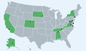
NASA graphic of geographic locations of DAACs
The Socioeconomic Data and Applications Center (SEDAC), based out of Columbia University in New York, integrates socioeconomic and earth science data. Their Global Covid-19 Viewer allows users to visualize spatially-explicit trends in COVID-19 infection and mortality rates concerning population- and location-specific risk factors. Their Hazards Mapper enables users to visualize data and map layers related to socioeconomics, infrastructure, natural disasters, and environment, and analyze potential impacts and exposure. Their POPGRID allows one to see high-quality, georeferenced data on population, human settlements, and infrastructure. And another tool, NASA Worldview, provides access to more than 1,000 satellite images in almost real-time.
People interested in working directly with NASA’s most commonly used Earth science data collections datasets can visit Earthdata Pathfinders. These guide users through selecting application-specific datasets and learning how to use them through intuitive tools, facilitating equal and open access to the breadth of NASA Earth science data. After getting started here, numerous NASA resources can help develop one’s skills further.
For those who want to participate in community science, GLOBE Observer is an international network of citizen scientists and scientists working together to learn more about our shared environment and changing climate. To participate, just download the GLOBE Observer app and submit regular observations. GLOBE Observer currently accepts observations of clouds, mosquito habitats, land cover, and trees, with planned expansion to future data types.
EDGI participants included Jessica Varner and Mark Chambers. Varner is interested in the applications of using data from the TEMPO satellite (Tropospheric Emissions: Monitoring Pollution), which will be launched later this year to monitor pollutants across North America. Mark Chambers, one of EDGI’s Civic Science Fellows, is looking at addressing gaps and lack of accessibility in governmental data provision and developing specific policy recommendations for how agencies can better bridge gaps between the data services they provide and communities’ interests and needs.